
-

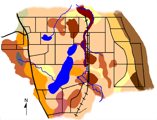
- BaD:
Bath channery silt loam, 15-25% slopes. Well-drained, strongly
acid, plowlayer, fragipan 18-30", moderately steep, limited
moisture retention. droughtyness in summer, rapid runoff, erosion
a potential problem.
-
-

- BoE:
Bath and Valois soils, 25-35% slopes. Well-drained, steep, strongly
acid, plow layer, good to fair moisture retention, very rapid
runoff, erosion a constsnt threat, fragipan in Bath components,
Valois components with no rooting restrictions.
-
-

- Fm:
Freshwater marsh. Permanently saturated to the surface, man-made
lake.
-
-
-

- Hc:
Halsey mucky silt loam. Deep, very poorly drained, water stands
at or within a few inches of the surface throughout the spring
and rises to the surface frequently. Holds water and nutrients
well.
-
-

- HdC:
Howard gravelly loam, 5-15% simple slopes. Deep, well-drained
, some areas with slight to moderate erosion. Slope increases
possibility of runoff, moderate ability to store water.
-
-

- HdCK:
Howard gravelly loam, 5-15% complex slopes. Deep, well-drained
to excessively drained, rapid runoff, moderate moisture storage
capacity, 5-15% of the acreage is slightly or moderately eroded.
-
-

- HdD: Howard
gravelly loam, 15-25% slopes. Rapid runoff in heavy rains, moist
areas with some erosion, moderate moisture storing capacity.
-
-

- Hpe:
Howard and Palmyra soils, 25-35% slopes. Well drained, good to
fair moisture-holding capacity, rapid runoff, erosion a constant
threat.
-
-

- HsC3:
Hudson silty clay loam, 6-12% slopes, eroded. Well-drained to
moderately well-drained, depleted organic matter content, rapid
runoff, moderately eroded (10% uneroded) with seriopus erosion
hazard, plow layer in relatively poor physical condition.
-
-

- HsD3:
Hudson silty clay loam, 12-20% slopes, eroded. Moderately steep,
plow layer, forested areas and a few pastured areas are uneroded,
subject to continuing serious erosion. Droughty (loses much water
to very rapid runoff).
-
-

- HzE:
Hudson and Dunkirk soils, 20-45% slopes. well-drained, most cleared
areas are moderately or severely eroded, plow layer.
-
-
-

- LoF:
Lordstown soils, 35-75% slopes. Very steep, forested valley sides,
soil depth ranges from none to 4 or 5 feet within short distances,
well-drained, droughty, ledgy.
-
-

- Ws:
Wayland and Sloan silt loams. deep, fertile, poorly drained to
very poorly drained, frequently flooded, wet-tolerant plants
dominant.
-
-

